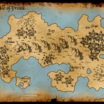
Geography
The Maps of Prentil:
Geography:
Prentil is roughly 1,000 miles wide and 600 miles north to south. In comparison to both size and climate, Prentil would stretch from the beaches of South Caroline west to the western side of Arkansas, north to Iowa, then east to the Deleware and New Jersey shores. The land is generally moderate in temperature, but occassionally the winters can be rough in the north. The Everstorm in the North East keeps the climate there particularly cool, but also keeps the snows to a minimum in the winter. Winters are worst north of Foyyt and Vridhan. Summers can be harsh in the southern portions of Bentl.
Travel Distance and Time:
Stennar to Bentyl: 1,000 miles, 6 weeks travel
Stennar to Gordon: 600 miles, 3 weeks travel
Gordon to Foyyt: 400 miles, 2 weeks travel
Foyyt to Slogat: 400 miles, 2 weeks travel
Slogat to Bentyl: 400 miles, 4 weeks travel
* all figures are estimates
* estimates based on safe horseback travel by road with nightly camping


Testaru. Best known
A few years back you had links on the website to a game based on this comic. I think the game had Vridhan in the name. What ever happened to that game?
It didn’t make it. There were only two of us working on the game and I barely had time for the game with with life and real jobs and trying to keep the comic going, so most of the work fell to my friend. He gave it his all but in the end it just turned out to be too much for the two of us. We even tried recruiting some other developers but it just didn’t pan out.
What kind of game was it? For a TTRPG, a lighter system would make it easier.
It was an RPG style game similar to Skyrim. I think we went too big.
Oof, yeah, that’ll do ya :/
Did you change the name of Gordon?
Yes, after we realized it was too close to Gondor. 😀
Was thinking Ramsey, or men wearing skirts having a fling in lands that are high 😛